General Information
Khorramabad is a city in and capital of Lorestan Province in Iran. At the 2006 census, its population was 328,544, in 75,945 families. Khorramabad is situated in the Zagros Mountains. Khorramabad Airport is 3 km south of the city proper.
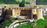
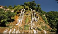
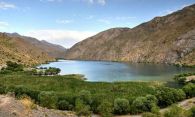
The city population is predominantly Lur and Lak, although the two groups are closely related. Although not a major tourist destination, it is quite scenic and possesses several attractions, such as 5 Paleolithic cave-dwelling sites. In the city center, a tall citadel called Falak-ol-Aflak (The Heaven of Heavens), a relic of the Sassanid era, is now a nationally popular museum. Economically, it is the regional base of the agricultural industry.
Get in and around
The airport located in the south of the city. There are daily flight from / to Tehran and Mashhad.
Well connected to freeways. You can use taxi, however the easiest way to travel is via a hired car and its not expencive.
There are plenty of scheduled bus services from some major cities.
Top sights & Things to do

When to visit?
The most popular time to travel is during the spring (Mar–May). The climate is warm and temperate in Khorramabad. In winter, there is much more rainfall in Khorramabad than in summer. The average annual temperature is 16.9 °C in Khorramabad. About 488 mm of precipitation falls annually. The warmest month of the year is July, with an average temperature of 29.6 °C. In January, the average temperature is 5.0 °C. It is the lowest average temperature of the whole year. The difference in precipitation between the driest month and the wettest month is 92 mm. The average temperatures vary during the year by 24.6 °C.
| Jan | Feb | Mar | Apr | May | Jun | Jul | Aug | Sep | Oct | Nov | Dec | |
| High/Low temperatures |
10°
-1°
|
13°
1°
|
17°
4°
|
22°
9°
|
28°
12°
|
35°
17°
|
39°
21°
|
39°
20°
|
34°
15°
|
27°
10°
|
18°
5°
|
13°
1°
|
|---|---|---|---|---|---|---|---|---|---|---|---|---|
| Chance of precipitation |
19%
|
17%
|
16%
|
21%
|
10%
|
1%
|
0%
|
0%
|
1%
|
7%
|
18%
|
17%
|